The fork for the road to the south (southeast actually), is at Lepoura, from which you can see both side of the island, though the narrowest point is farther south. This very different part of Evia shares both geological and ethnic similarities with the northern Cycladhic island of Andhros off its southernmost tip. Both have marble and slate, and Arvanitika (a medieval dialect of Albanian) was spoken as a first language in many villages up until recently in both places as both areas had been settled by Albanians from the fifteenth century on. Ancient Dystos which consists of a few fifth century BC ruins, is on top of a hill in the basis of a large lake that was drained for farmland, eliminating yet another wetland for migratory birds. There is a ferry crossing to Ayia Marina (on the mainland) at Nea Styra to the south, as well as a resort.
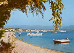
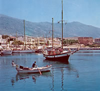
Styra (Nea Styra beach far left), the hill village above it, is known for its Drakospita (Dragon Houses), made of enormous blocks of masonry. These structures can only be reached by trail, and may have been sixth century BC temples. The ferry link with Rafina is further south at Marmari. The main town of southeastern Evia is Karystos (harbor near left) (population 4500) which sits on a good bay below Mt. Ohi (1398 meters/4585 feet) and has nice beaches and a resort. The town isn’t terribly exciting though, designed on a Bavarian grid plan by an architect in the hire of of King Otho, though there are some neoclassical buildings. The ruins of a fourteenth century Venetian castle-the Bourtzi, sits along the waterfront (background R pic right above). This is a tower, which was once part of extensive fortifications. Opposite the tower is the archaeological museum (Tues-Sun 8am-3pm;1.50 euros). It exhibits mostly temple carvings, statues, and votive offerings.
See our Greece hotels for a complete look at accommodations available on this island.
This is a very nice island to explore by car, driving up the mountainous forested spine that heads northwest. Psahna and the Dherveni gorge mark the ‘gateway’ to the north. 52 km from Halkidha you reach the agricultural village of Prokopi in a wooded valley, a village settled by refugees who came in 1923 from what was then called Prokopion in Turkey (now Urgup in central Turkey, in Cappadocia). The Orthodox Greeks from that region brought the mummified remains of a Ukrainian soldier captured by the Ottomans in the 18th century and taken to Turkey where he died. whom they called Saint John the Russian, because his dried-up remains were said to have performed miracles.

Why not enjoy Harry's Free Musical Compositions while you read this site? (opens seperately)
©Harry's Greece Travel Guides